
INTRO MAP
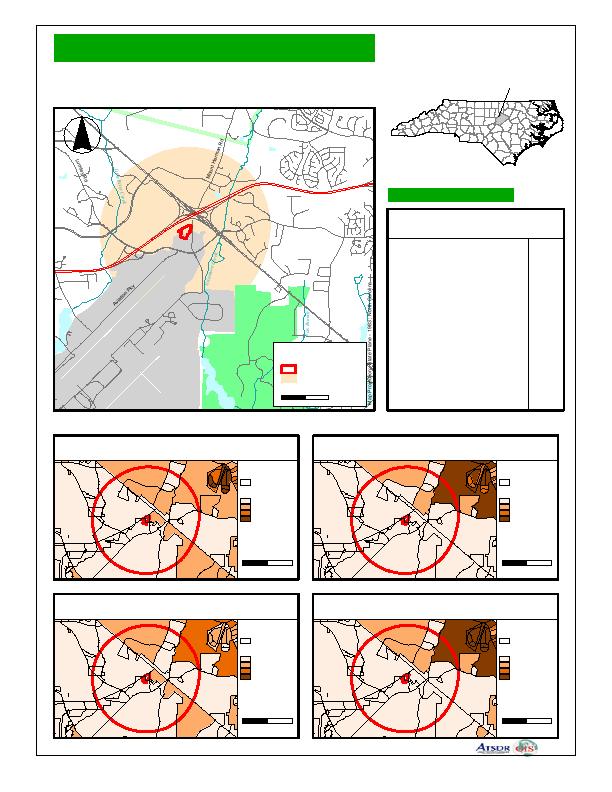
Ward Transformer
Raleigh, North Carolina
Site Location
EPA Facility ID NCD003202603
#
Durha
m
Coun
ty
Lees
ville
Rd
Leesville
Rd
(
/
70
.
-
,
540
Wake County, North Carolina
Demographic Statistics
Westg
Raleigh
ate Rd
Within One Mile of Site*
.
-
,
540
104
Total Population
White alone
88
Black alone
10
0
Am. Indian and Alaska Native alone
4
Asian alone
Native Hawaiian and
0
Other Pacific Islander alone
(
/
WILLIAM B UMSTEAD
70
STATE PARK
Some other race alone
0
Two or More races
1
RALEIGH-DURHAM
2
Hispanic or Latino
Legend
INTERNATIONAL AIRPORT
12
Children Aged 6 and Younger
Site Boundary
5
Adults Aged 65 and Older
One Mile Buffer
25
Females Aged 15 - 44
0
0.3
0.6 Miles
39
Total Housing Units
Base Map Source: 1995 TIGER/Line Files
Demographics Statistics Source: 2000 US Census
*Calculated using an area-proportion spatial analysis technique
Population Density
Children 6 Years and Younger
Source: 2000 U.S. Census
Source: 2000 U.S. Census
US Census Block
US Census Block
Zero Population *
Zero Population
>0 - 1000 *
1 - 9 Children
>1000 - 2000 *
10 - 20 Children
>2000 *
> 20 Children
* Persons / Sq. KM
0
0.5
1
0
0.5
1
Scale in Miles
Scale in Miles
Adults 65 Years and Older
Females Aged 15 - 44
Source: 2000 U.S. Census
Source: 2000 U.S. Census
US Census Block
US Census Block
Zero Population
Zero Population
1 - 9 Adults
1 - 9 Females
10 - 20 Adults
10 - 20 Females
> 20 Adults
> 20 Females
0
0.5
1
0
0.5
1
Scale in Miles
Scale in Miles
JVA120302
3

 Previous Page
